
TL:DR – In 1983, Vernal Holley proposed a list of names and corresponding maps to prove the Book of Mormon setting was based on the Great Lakes region (and therefore fictional). Holley presented 29 modern place names as inspiration for locations in the Book of Mormon (out of 86 unique Book of Mormon geographical names). Based on new research, 17 of those proposed correlations can be proven invalid. However, church critics can still legitimately point to 16 correlations as possible sources of plagiarism. Confused? Details below.
Over thirty years ago, church critic Vernal Holley published a pamphlet arguing a new spin on the old Spaulding hypothesis. Included in this book was something special, a list and maps Holley compiled as evidence to prove the setting of the Book of Mormon was a fictionalized version of the 19th century Great Lakes region (a technique Spaulding used). While the Spaulding theory remains unpopular, Holley’s list and maps have had limited staying power in the disaffected Mormon community as proof of Joseph Smith’s authorship of the Book of Mormon.
Until the publication of the CES Letter in 2013, Mormon apologists largely ignored Holley’s maps. As Michael Griffith put it, “Holley’s analysis of the geography of the Nephite record (31-41) is simply not to be taken seriously.” In the first thirty years, only two apologists appeared to put effort into proper analysis of Holley’s theory. The first was L. Ara Norwood, who wrote a review of Holley’s Book of Mormon: A Closer Look in the 1989 inaugural issue of Mormon Studies Review Review of Books on the Book of Mormon (later known as The FARMS Review or, currently, Mormon Studies Review). Norwood said,
Perhaps the most innovative portion of the study is the section on geography. Several anti-Mormons shouted with glee when they first laid eyes on the map of proposed Book of Mormon lands shown side by side with the map of New England (see figs. 1 and 2), while some LDS scholars looked forward to studying the maps since it seemed that a fresh point of attack worthy of scrutiny had finally reared its head. (p. 84-85)
Norwood undertook a deeper study of Holley’s geography argument, and presented a summary of his findings as part of the review. The first problem he noted was Holley’s maps contradicted the internal geography of the Book of Mormon (because, obviously, everyone agrees on what the Book of Mormon says about it’s own geography). Next, he pointed out many names Holley proposed were biblical, so Joseph wouldn’t have needed Spaulding’s manuscript to come up with them. Finally, he cited two examples of cities on the list incorporated long after the Book of Mormon was published (Angola and Jerusalem), suggesting Holley was “chronologically misinformed.” For many years afterwards, Norwood’s 5 paragraphs on the matter were the de facto official apologetic response to any mention of Holley’s maps (see this 2005 discussion, for example).
In 2007, apologist Jeff Lindsay responded to a commenter’s challenge concerning names from Holley’s list. Lindsay discussed six of those names, laid on the biblical argument (why would Joseph use maps when he could just pick up his bible?), and finished with a dramatic parallelomania Hawaiian flourish. The FairMormon group picked up on this post and used his (non-Hawaiian-related) arguments as the foundation for their Vernal Holley Book of Mormon geography section (as seen on this remote corner of the site that has somehow avoided updates). It was this FairMormon defense Jeremy Runnells consulted before including the Vernal Holley maps in his CES Letter.
How do I know? Under the FairMormon section “Names that didn’t exist in Joseph’s day” were listed three towns: Sainte Agathe, Angola, and Tecumseh. Two of these, Angola and Tecumseh, had debunking arguments straight from Lindsay’s post. The other, Sainte Agathe, was added in 2009 by another volunteer. When Jeremy pilfered his Holley list from the Maze Ministry website, he omitted those three towns before publishing the CES Letter.
Runnells recognized something that apologists failed to grasp for years. The best arguments against the Vernal Holley maps weren’t about matching internal Book of Mormon geography cues, crediting the bible as a source, or parallelomania. It’s about verifying which towns were actually available for Joseph Smith to plagiarize in 1829. But, since apologists hadn’t put in much effort on that front, Runnells felt comfortable including a theory even he felt was pretty weak. In this case, an ounce more of apologetic prevention would’ve truly been worth a pound of cure. (Seriously, apologists had thirty years to build a better argument before the CES Letter came out.)
The CES Letter breathed new life into the Vernal Holley maps, giving them a much wider audience than ever before. One benefit of the subsequent debunking and counter-debunking were token efforts by those on either side of the debate to back up their positions. FairMormon and NephiCode represented the best of the best for apologists, and Runnells reluctantly stands as the best Holley defender on the church critic side. But… I find the arguments so disappointing. I decided to do the research and get the data I’d want to find if I were looking into the Vernal Holley maps for the first time. If you aren’t up for reading the text, just scroll through and look at the pretty pictures.
Laying the Groundwork
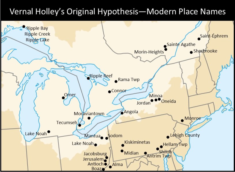
There are at least four versions of Vernal Holley’s maps: an original reprinting in Phil Hart’s The Book of Imaginary Indians (2008), a later edition in Norwood’s 1989 review, the Maze Ministry version (used in the CES Letter), and the latest edition on Dale Broadhurst’s Solomon Spalding website. They all differ slightly, and none contain all the geographic names proposed by Holley, so I made my own map. (I only care about the modern places, so I didn’t create a Book of Mormon version.)

One name from Holley’s table I refuse to put on the map is “Tenecum.” At no point has the word Tenecum been associated with either the historical figure Tecumseh or any locations bearing his name. Tenecum is an old spelling of the island on the Delaware River where Swedish colonists built a fort in 1643. The name was derived by the Lenape name Tin-eek Unk. By Joseph Smith’s time, the standardized spelling Tinicum was used in reference to adjoining townships on the Delaware River in both Bucks County and Delaware County Pennsylvania (see this 1823 gazetteer).
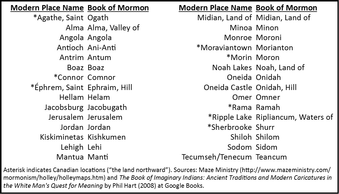
One other thing. Sometimes you’ll have apologists compare the 29 (or so) names on Holley’s table with 345 names in the Book of Mormon. That’s deceptive. Book of Mormon study guides over at the BYU Studies website show only 95 geographical names in the book. Taking out the four without proper names (land northward, land southward, narrow neck, and narrow pass) and the five duplicates (Desolation, Nephi, Onidah, Sherrizah, and Zarahemla), only 86 geographical names are left to compare with Holley’s theory.
What Apologists Want to Hear
In approaching Holley’s hypothesis, it’s easiest to start with the problems.
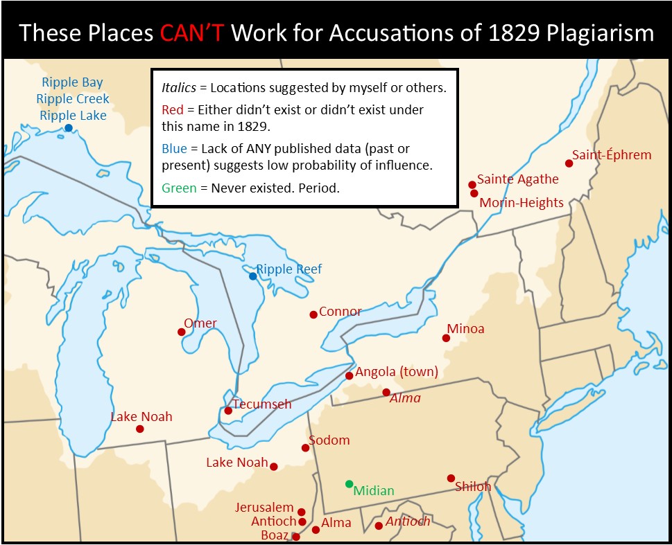
Saint Agathe (as the place Ogath) – Apologists picked up on this one early because it’s easily solved by Wikipedia. Just for fun, I’ll link to a different website which confirms the area that became Sainte-Agathe-des-Monts in Quebec didn’t have European settlers until 1849.
Alma (as the valley Alma) – Holley’s maps show he was referring to the community in Tyler County, West Virginia. Wikipedia suggests the neighboring communities of Centerville and Alma are the same, but they aren’t. The important thing is that Alma wasn’t always Alma. According to History of Tyler County West Virginia to 1984, “The area where they settled is known as Alma today, but originally was named Ripley after the Ripley family. The name was later changed due to the confusion with the other Virginia village of that name. Alma was chosen, named for a granddaughter of William Ripley” (p. 424). This granddaughter, Alma Beatrice Pierpoint, was born in 1884 (which explains why this 1873 map shows the community as Ripley.)
Alma, Allegany County, New York, is often given as a viable alternative, but it doesn’t work. The community was settled in the early 1830s, and at the time went by the names Honeoye, Honeoye Corners, or Shongo. (There are various theories for how it later got the name Alma.)
Angola (as the city Angola/Angolah/Angelah) – This one seems really easy. Wikipedia says the town was previously called Evans Station until 1854 or 1855. But… they got the name Angola because a different post office with the same name closed down, and that nearby post office was around in 1829. So this alternate Angola is available for church critics to use, and I’ll say more on that below.
Antioch (as the village Ani-Anti/Anianti) – FairMormon refuses to address this one because Holley and Runnells misspelled it as Anti-Anti. Seriously. Anyway, according to Holley’s first map, he meant Antioch in Monroe County, Ohio. Unfortunately, this town wasn’t laid out till 1837, and… it was first named Jarvistown in honor of the founder (Monroe County, Ohio: A History, by Theresa A. Maienknecht and Stanley B. Maienknecht, 1989, page 326).
I thought I found a legitimate alternative with Antioch in Mineral County, West Virginia, because Wikipedia says it was settled in 1787. But it didn’t get the name Antioch until 1880.
Boaz (as the city Boaz/Beaz) – The only option in the Great Lakes region is Boaz, Wood County, West Virginia. Wikipedia explains, “The community was named in 1878 by the United States Post Office Department, which selected from three names suggested by a resident named William Johnson: ‘Johnson,’ ‘Ruth,’ and ‘Boaz.'”
Connor (as the hill Comnor/Comron) – This name only appears on one map of Holley’s and it’s obviously misplaced as later maps all show the same spot as Sherbrooke. But Holley noted this was in Canada (because the Book of Mormon corollary is in “the land northward”), and there is a community named Connor in Simcoe County, Ontario. A history of the township, Adjala by Francis Vincent McDevitt and Mary Margaret Munnoch (1993), says residents requested that name in honor of their hometown in Ireland when the post office was established in 1865 (p. 149). Connor doesn’t show up on an 1853 map of the township in that book (p. 27), confirming that later date of origin.
Saint Éphrem (as the hill Ephraim) – Again, a simple Wikipedia fix. Based on the maps, Holley clearly meant the community of Saint-Éphrem-de-Beauce in Quebec. A municipality first bearing the name Saint-Éphrem in that area was established in 1866, Saint-Éphrem-de-Tring. The name Saint-Éphrem-de-Beauce came later. Either way, too late for Joseph Smith.
Jerusalem (as the city and land Jerusalem) – Okay, this one made me angry with Jeremy Runnells. Holley’s maps clearly indicate he meant Jerusalem, Monroe County, Ohio. Runnells made a big deal about how he was able to get a local resident down to the Monroe County Public Library and locate a book that said the first house was built in Jerusalem in 1825, making it eligible for 1829 plagiarism. He even included a picture of the cover of the book. I found the same book at the Family History Library in downtown Salt Lake City. Here’s what it said: “The first house was built in 1825 by James Vernon. The second house was built by Noah Stevens in 1838. By 1847 there were only three residences in the area that was to become Jerusalem” (Monroe County, Ohio: A History, by Theresa A. Maienknecht and Stanley B. Maienknecht, 1989, page 285). One house does not a town make. However, there are other good alternates for towns named Jerusalem in 1829. More on that below.
Land of Midian (as the land Midian) – A modern-day land of Midian is shown in Pennsylvania on the Maze Ministry map. Unfortunately, the only Midian (past or present) in the United States is in Kansas.
Minoa (as the land Minon) – The only option in the United States is Minoa, Onondaga, New York. Wikipedia: “It was known as “Manlius Station” – a stop on the Syracuse-Utica railroad (completed in 1839) – until the name was changed to Minoa in 1895.”
Morin (as the land Moron) – Based on Holley’s maps, he clearly meant Morin-Heights in Quebec. According to Wikipedia, “The first European settlers arrived from Ireland around 1850, followed by French Canadians from Lachute, Saint-Jérôme and Saint-Eustache. In 1852, the Morin Township was formed…”
Noah Lakes (as the city and land Noah) – These don’t show up on any of Holley’s maps, but the only two options I can find are Lake Noah in Summit County, Ohio, and Lake Noah in St. Joseph County, Michigan. Unfortunately for Holley, Lake Noah in Summit County is not natural. It was likely made when they put in the nearby Nimisila Reservoir in 1936. An 1874 map of Green Township in Summit County shows what the area looked like before the reservoirs were put in. As for the lake in Michigan, it also seems to have been affected by human activity. On an 1872 map of Lockport Township in St. Joseph County all you see is a tiny unnamed pond on the property of a Mr. J. George Ott where Google now places Noah Lake, and it’s nowhere near the size of what maps show today.
Omer (as the city Omner) – not shown on any version of Holley’s maps. Since Holley indicated the town was in the United States, the likeliest spot is in Arenac County, Michigan, close to Lake Huron. Settled in 1866, the community was originally called Rifle River Mills. Omer currently holds the honor of being the second smallest city in the state of Michigan.
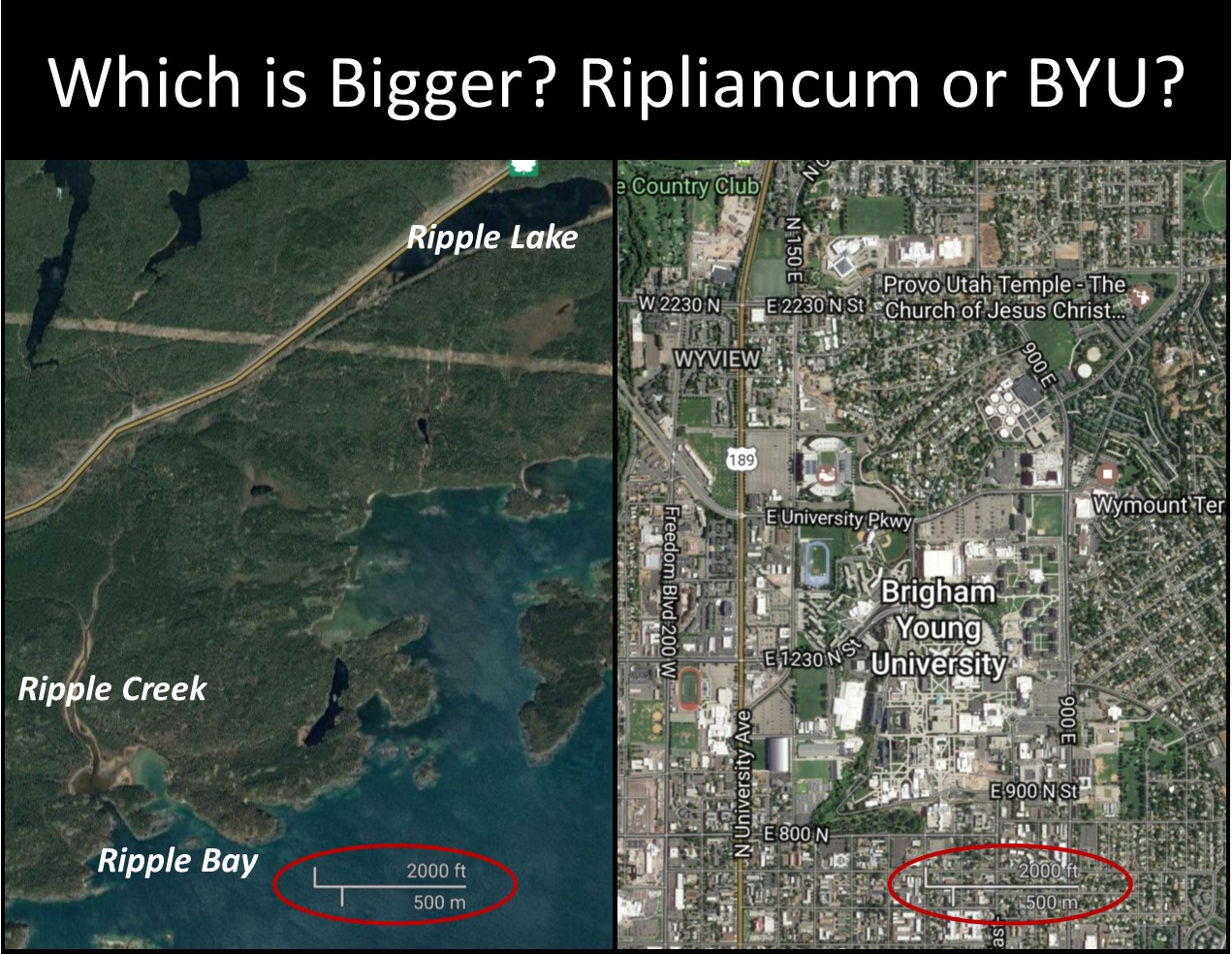
Ripple Lake (as the waters of Ripliancum) – I don’t know how in the world Holley came up with this other than looking at an index of all names used on topographical maps in Canada (that’s the database I had to use, anyway). Holley makes a big deal about the occurrences of Ripple Lake, Ripple Creek, Ripple Bay, and Ripple Reef as possible influences for the name Ripliancum. The only one I can find in ANY published records is Ripple Reef of Lake Huron in a modern Great Lakes pilot guide. Google maps can’t find it, though. The other three features are located far away along the remote north shores of Lake Superior. A train stop named Ripple was put there in the late 19th Century when the Canadian Pacific Railway was built. No idea if the station was named after existing water features or if the water features were named after it. To give you a scale of how small the area is containing Ripple Lake, Ripple Creek, and Ripple Bay, I created a graphic comparing it to the BYU campus in Provo. There’s no way this works for 1829 plagiarism.
Shiloh (as the city and land Shilom) – Based on his maps, Holley meant Shiloh in York County, Pennsylvania. That community didn’t get the name until the turn of the century. According to a local news website, “Michael Brown and Danny Naylor are credited with naming the farming village of Shiloh. When trolley tracks connecting Dover and York City were going in circa 1900, the pair realized that the tracks would create the need for a station where the trolley crossed Church Road. That crossing would need a name other than ‘the village near Weiglestown.’ Naylor was a member of Shiloh Union Church, so the name was attached to the village.” Although there are many rural communities using the name Shiloh in the United States, I haven’t been able to find any in the Great Lakes region clearly established before 1829.
Sodom (as the land Sidom) – Based on his first map, Holley meant Sodom in Trumbull County, Ohio. According to local histories, though, the community acquired the name Sodom around 1840. There are, however, several small communities in New York that went by the name Sodom at one time or another before 1829. More on that below.
Tecumseh (as the city and soldier Teancum) – Holley makes a big deal about the similarities between the Book of Mormon Teancum and Morianton with the historical figure Tecumseh and Moraviantown. He cites the current town of Tecumseh in Essex County, Ohio, openly admitting that it only received that name in 1912. If someone were to argue about 1829 plagiarism, I’d much prefer they use places with that name existing at that time, and I give a couple options below for Tecumseh.
What Church Critics Want to Hear
And now the other side of the coin…
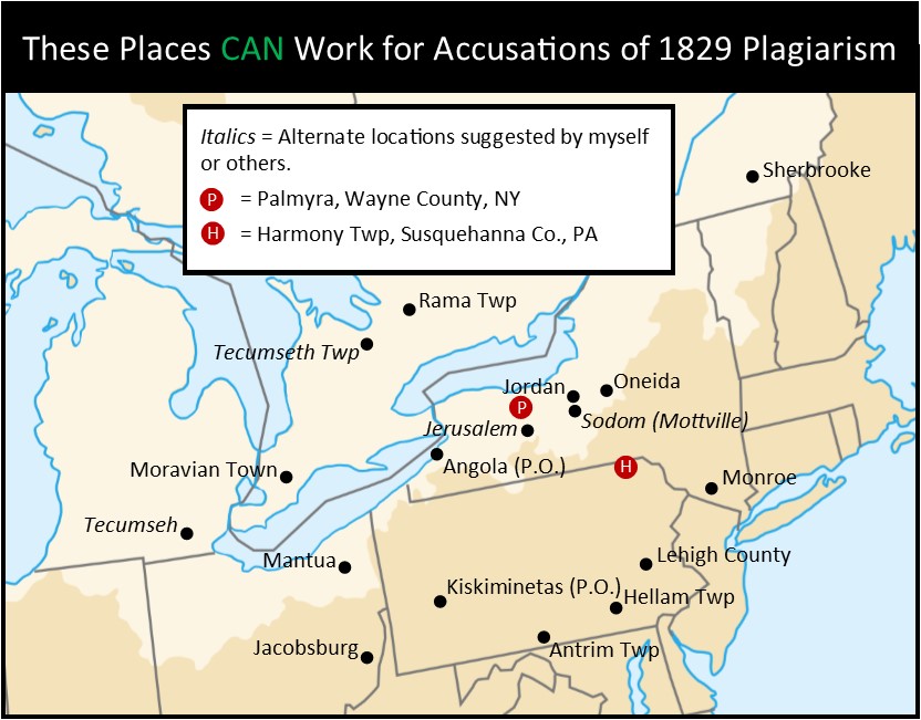
Angola (as the city Angola/Angolah/Angelah) – A post office named Angola was established in 1822 in Taylor’s Hollow, a hamlet in the town of Collins, Erie County, New York. It was the first post office in Collins. It closed in 1855, and the name was transferred to the current town of Angola, New York. It is cited in the 1825 version of the United States Official Postal Guide (page 5).
Antrim (as the land Antum) – Antrim Township in Franklin County, Pennsylvania, was created in 1741. It appears in the 1823 New Universal Gazetter (page 45). There are other locations in the Great Lakes region also named Antrim by 1829.
Hellam (as the city and land Helam/Helem/Helim) – Hellam Township in York County, Pennsylvania, was founded in 1739. It was named after a Hallam Township in England, and the Pennsylvania township was often spelled Hallam in the early years. This is how it appears in the 1823 New Universal Gazetter (page 310). Interestingly, a map of York County made between 1816 and 1826 shows the name as Helam.
Jacobsburg (as the city Jacobugath/Jacob-Ugath) – Sometimes referred to as Jacobstown in early literature, this town in Belmont County was laid out in 1815. It is cited as Jacobsburg in the 1825 version of the United States Official Postal Guide (page 46).
Jerusalem (as the city and land Jerusalem) – Jerusalem in Yates County, New York, is the place you can best argue might have influenced Joseph Smith, though several other smaller communities in New York also used the same name. It was established around 1791 in Ontario County, before Yates County was formed. It’s only 33 miles south of Palmyra, and the 1823 New Universal Gazetteer notes it had a population of 1,610 at the time (page 359). I’m a little bugged that FairMormon dismisses it based on a map argument.
Jordan (as the city Jordan/Jordon) – The village of Jordan in Onondaga County, New York, was first settled around 1800. The village became a major transportation center with the construction of the Erie Canal in the 1820s. It is cited in the 1825 version of the United States Official Postal Guide (page 47).
Kiskiminetas/Kishkemanetas (as the city Kishkumen) – This is a reference to the Kiskiminetas River along the border of Armstrong County and Westmoreland County in Pennsylvania. There are various spellings of this name, though the most common I’ve seen are Kishkemanetas on early maps (see it on an 1805 map of Pennsylvania) and the standardized Kiskiminetas. Although the township of the name wasn’t established until 1831, somewhere in Westmoreland County there was a post office named Kiskiminitas. It shows up in the 1825 version of the United States Official Postal Guide (page 49).
Lehigh (as the land Lehi-Nephi) – the area of Lehigh County, Pennsylvania, was settled in the 1700s, though the county itself, named for the Lehigh River, wasn’t established until 1812. It’s in the 1823 New Universal Gazetteer (page 401).
Mantua (as the city or land Manti) – The area of Mantua in Portage County, Ohio, was first settled just ahead of 1800, though the township of the name wasn’t formed until 1810. The community was named in honor of Napoleon, who captured Mantua, Italy, in 1796. It is cited in both the 1823 New Universal Gazetteer (page 446) and the 1825 version of the United States Official Postal Guide (page 56).
Monroe (as the city or land Moroni) – Sooo many cities and counties are named Monroe in the 1820s. I mapped the town in Orange County, New York, but you could probably find one closer. It (and many others of the same name) is cited in the 1825 version of the United States Official Postal Guide (page 60).
Moravian Town/Moravian Village (as the city and land Morianton/Morionton) – Most early publications and maps refer to the community as Moravian Village (see this 1826 map of Canada, for example). However, the 1819 publication The Late War (a favorite among church critics) notes it as Moravian Town (page 115).
Oneida & Oneida Castle (as the place or hill Onidah/Oneidah) – Oneida County, New York, was created in 1798. The village of Oneida Castle was organized in 1815, though it previously held that name for many years. Both Oneida County and Oneida Castle are in the 1823 New Universal Gazetteer (page 553).
Rama (as the hill Ramah) – Even though Rama Township in Simcoe County, Ontario, wasn’t surveyed or settled until the 1830s, the township was named in 1820. It appears on an 1826 map of Canada.
Sherbrooke (as the valley Shurr) – This one’s a little tricky. The town of Hyatt’s Mills in Quebec had it’s named changed to Sherbrooke in 1818, so it definitely existed before 1829. However… I haven’t found any publications or maps with the Sherbrooke name before 1829 (1831 is another matter).
Sodom (as the land Sidom) – This is another tricky one. Many small communities in New York were called Sodom around the 1820s, though most did not retain that name. One is Mottville in Onondaga County, New York, which I included on the map. I could just as easily have chosen Nicholville, St. Lawrence County, New York, or the Sodom hamlet in Johnsburg, Warren County, New York. But, I don’t have publications from the 1820s to offer with these communities.
Tecumseh (as the city and soldier Teancum) – Holley really wanted this to be in “the land northward,” so a Canadian option for this is Tecumseth Township in Simcoe County, Ontario. The name was given in 1821, and settlers arrived soon after. The township is depicted on an 1826 map of Canada. An American option is, of course, the city of Tecumseh in Lenawee County, Michigan. The city was established in 1824, and appears on many maps of the 1820s. The town is also cited in the 1825 version of the United States Official Postal Guide (page 92).
While I’m a believing member of the church, I have to admit, it’s been fascinating to dive into this theory. The ball is now firmly in the court of church critics, though. Ideally, they would come up with more names to support the theory (16 out of 86 isn’t incredibly impressive), but, at the very least, they need to prove Joseph Smith had access to publications with these towns. (I don’t know that it will be all that hard. I always figured Palmyra was a podunk town, but the 1823 New World Gazetteer makes special note the village was “a place of considerable business” and had a population of 3,724.)
What do you think? Is there some merit to the Vernal Holley theory, or is it all bunk?
Discuss.

Wow you’ve done a lot of research here. That’s impressive!
I think I saw this once and it was never very convincing to me. I didn’t give it the time of day, but I’m impressed with what you’ve uncovered! Maybe FARMS should hire you?
Mary Ann, my opinion of your technical chops just went up SEVERAL notches.
I will have to say that even back in early morning seminary when we were quizzed on some of the geography of the BOM (central America of course at that time) I found it hard to keep my eyelids open. I have never been that interested in getting out the 500 piece puzzle and trying to figure this all out. Maybe it is just the association of this topic to my sleep-deprived seminary years that gives me a mental block.
But I have to commend you on an admirable exploration of the topic. VERY impressive.
Aww, thanks, guys!
Good to have fun with things like this.
Palmyra feels like a podunk town now, but it’s important to bear in mind that it was part of the canal system of transportation that was briefly in vogue during Joseph Smith’s day. As a result, it was kind of a boomtown, newly connected to the surrounding areas. The population rose from 2,187 in 1816 to 4,613 in 1825! Because it had rapidly become such an important transportation hub, it seems likely that many in the city were well aware of nearby cities that were transporting through there. Joseph’s home was actually in nearby Manchester (a smaller, less significant town) a few miles away.
Really interesting stuff, Mary Ann.
I agree that the Erie canal system was a veritable highway – he would’ve been exposed to a lot more than I thought.
Joseph’s home was on the border between Palmyra and Manchester townships, but since the town of Palmyra was at the south end of Palmyra township, they were much closer to that (only 2 miles away) than to the town of Manchester farther to the south (5+ miles away).
As stated before, your research is impressive! I’d put this together with Emma’s statement that Joseph didn’t have the ability to invent such a book, and totally dismiss Holley.
On a separate note, since many of these locations got their names after the BOM publication, would you consider that any former Mormons may have influenced their naming?
Charlene, that’s doubtful. In looking up the histories, they usually explained how the name came about, and none of these towns had obvious Mormon connections. A lot of the biblical names were because they took names from local churches (Saint Ephrem and Shiloh, for example), or people just wanted more dignified names (both towns of Antioch in this case). Some were named after people, like Morin and Alma (WV). The Alma in New York is disputed – one theory is it’s from Dr. Stephen O. Alma, the first superintendent of an important lumber company in the area. Other people think a guy just really liked the Crimean War, and suggested the name from an 1854 battle on the River Alma. Boaz seems to be just a personal preference (since there were three names given as options). Omer was because the guy wanted to name the place Homer, but another Homer already existed, so he just dropped the first letter. Sodom (OH) was from a snide comment a minister made after unsuccessfully preaching in that community, and the people found humor in it. Connor came from the Irish town. You can chalk any similarities to Book of Mormon names as coincidence on almost all the disqualified towns.
Yeah, a lot of these names are not that uncommon for the time & place. Others (usually derived from Native American dialects) are more of a stretch to get to, but are the only ones that seem remotely compelling to me.
Right. Oneida is really the only strong one to me. I could see Lehigh, but the fact he used the biblical spelling (Lehi) and paired it often with Nephi, a name from the Apocrypha, makes me think a religious text argument is stronger. One thing about the argument that gets me, though, is why he would’ve picked these names. When you look at the most common maps of the area, or even the gazetteers, there are *so* many cooler names to pick from.
Wow! Very interesting article! As always you are killing it!
Ramble warning, bear with me.
One of the most fascinating stories in the Bible is in I Sam 28. King Saul consults a witch to summon the ghost of the dead prophet Samuel who accurately predicts his death and that of his son in battle the next day. My premise is a family like that of Joseph Smith with their strong interest in folk magic and familiarity with the Bible would be nothing less than obsessed with this disturbing passage describing Biblical folk magic. Having in mind a list of unfamiliar names might be useful while practicing folk magic out in the woods at night, calling up or denouncing folk spirits that might be involved. (Example: I command the spirits of Oneida and Teancum to leave off guarding the buried treasure of the piratess of Mary Ann, mistress and secret heir of Sir Henry Morgan).
.
Several years ago I looked at all the proper names in this chapter and in the 2 chapters before and after it. There are quite a number of unfamiliar names that I could image using while telling campfire stories. My hypothesis was that a confabulating Joseph Smith might use his favorite parts of the Bible for inspiration in creating unusual names in the Book of Mormon. He might only use parts of names and re-combine them together. He might use more than one Biblical passage so not all unique Book of Mormon names need be found in one concentration. He might be clever enough to hide this for a couple of centuries. What gives me the edge over most scholars is that I have become somewhat of an expert telling scouts stories around fires at night and better appreciate the methods he might have used.
I made a list of all proper names in these 5 chapters. I excluded names so common as to be not useful in discriminating this as a source such as David and Saul. (I notice this is not done above and weakens the case.) I looked at the pronounciation list in the back of the Book of Mormon. I found maybe half a hundred similarities.I was astonished at the number of names I found, often by combining parts of two words. I selected another Biblical passage with lots of unusual names somewhere else (I can’t remember) and only found a few such similarities which might be likened to background noise. I wrote this up and submitted a paper to Sunstone magazine and it was rejected as flippant and too much speculation. I do not want to repeat the amusing project tonight, it took too many hours and required a level of imagination that I no longer possess as senility overtakes me.. But here are a few parallels that float up out of my memory….
Wilderness of Ziph -metal of ziff (1 Sam 26:1)
Jeshimon=> many names end in –mon including Mormon, Ammon, etc (1 Sam 26:1)
Nabal => Laban spelled backwards (1 Sam 30:5)
Abiathar => Abinadah (1 Sam 30:7)
Zeruiah and Ahimelech (1 Sam 26:6) Say both names real fast 7 times and it suggests Zerahemla older spelling of Zarahemla
.
And while confirming citations I notice Shur is in 1 Samuel 27:8 which is better than Sherbrooke on the Vernal Holley map chart above.
I think the Vernal Holley map project is doing the same thing I was doing and it is not half as good. (No metric to measure any of this.)
When you ask a question (Where did young Joseph come up with all those unusual names?) and get too many answers, I think all of them might be suspect; since they are not compelling enough to exclude each other. The logical trap of parallelmania: If you look long enough coincidental parallels will appear , doesn’t prove anything.
As a writer of fiction, who was already seriously doubting the church’s truth claims, the map basically sealed it for me. It was so obvious that this was where he’d gotten it, just as it’s now obvious where he got the style of prose (the KJV and contemporary KJV-alike fiction like The Last War), the characters (rampant speculation about “Indians” being the lost tribes of Israel), the plot (long rambling stories he used to tell his family), and the theology (stuff that was hot in his day and that everyone was discussing).
The burden is not on “critics” (basically everyone who isn’t Mormon) to prove anything. The neutral hypothesis, that everyone else already assumes, is that he made it up. If there are false positives, like in this article, it’s because people are speculating about what influenced him, not outlining a shaky hypothesis that depends on every point being correct.
For example, the city of Moroni is the capital of the East African island nation Comoros, which apparently featured in stories of buried treasure which were contemporary with Smith. That this is where he got the Hill Cumorah and the angel Moroni is pretty much a given. It’s possible, though, that someone might find “author’s notes” which suggest a different origin, or that new evidence might cast doubt on whether or not he’d had access to those specific stories. But that doesn’t change the neutral hypothesis, or the fact that it’s still the best-supported.
… plus, it seems really unlikely that that isn’t where he got those two names. I mean, really.
You know, I’ve been itching to look into that Comoros Islands theory. The fact that the modern-day city of Moroni is on Grand Comoros Island but Jeremy Runnells keeps passing around a 1748 map of a different island in the group (Anjouan/Johanna) as evidence really bugs. I also haven’t seen anyone come up with a Captain Kidd publication from that era with those two place names. Just seems shoddy on the research front. Maybe that’ll be my next post.
Have fun ~
Incidentally, I didn’t leave until after I’d looked into truth claims stuff, but I didn’t look into that until I realized the LDS church wasn’t one that my conscience would let me support anymore … not with my words, not with my money, and not with my actions. Not when it was hurting people I cared about, and not when I knew that God didn’t want LGBT+ people to be hurt.
I was just like “But what about this and this? Oh .. oh. I guess that explains that.”
Even if I knew it to be “true,” in the way Mormons say that they know, I still would have had to leave for the sake of my loved ones. And, as I eventually realized, myself.
Jewelfox,
You might be interested in this article by a philosopher with two doctorates named William Lane Craig. It addresses homosexuality in a Christian context. I think you’ll be very surprised by the article; it’s probably not at all what you’re thinking it is. http://www.reasonablefaith.org/a-christian-perspective-on-homosexuality
Jewelfox,
You probably already know what to expect from William Lane Craig, and I can tell you that you will not be surprised by the article at all.
I disagree with the soft conclusion. I do appreciate the research here, but it doesn’t help the critic. The critic relies on the idea that so many name matches “can’t just be a coincidence” – but what you’ve shown is that many of these names popped up pre-1830 and then INDEPENDENTLY popped up again, post-1830. That’s the very coincidence the critics say is too improbable.
In addition, you could compile a list of “known coincidences” from all the Book of Mormon names which pop up post-1830. Those are presumably all coincidences, and the existence of the “known coincidence” list refutes entire critical argument.
I guess I’m officially spamming the comments now, three in a row, but I do think the point I’m making is worth trying to explain.
Basically, the same people who are amazed at a list of pre-1830 name matches, and declare that it couldn’t be a coincidence – those SAME people dismiss all the post-1830 names without realizing that the post-1830 names are JUST AS BIG of a coincidence.
In other words, if we agree the Book of Mormon did not influence the post-1830 name matches, then we must concede that their resemblance to Book of Mormon names is mere coincidence. And yet, when we compile all those names together, we end up with an impressive list of names which all sides concede are coincidences.
Therefore, the post-1830 name matches prove that the pre-1830 name matches are no big deal.